|
SinaiSinai; land of discovery. The route to the Promised Land; where Isis sought Osiris and the Pharoahs found gold. Where Moses witnessed the burning bush and Bedouins camped by Crusader forts. A meeting point for three great religions, at the crossroads of Africa and Asia. After 80,000 years at the heart of history, experience the continuing contrasts. Sinai: where rock meets coral reef and the desert stops at the sea. Where the grandeur of granite meets the golden beaches of the " Red Sea Riviera ". Tropical Fish and rare birds; spectacular sunsets and clear starry nights. Sinai - by its geographical location - is the junction between Asia and Africa. It is shared like an inverted triangle, with the base stretching between Rafah and Port Said, in the north, and the apex, Ras Mohammed, in the south. This prominent and strategic position of the Sinai Peninsula has made it the gateway to Egypt from the east. Sinai’s history goes back to the Pharaohs who explored its land, searching for gold, copper and turquoise. Thus, it came to be known as the Land of Turquoise. Sinai is rich in scenery. To the north, palm-shaded sandy beaches stretch along the Mediterranean shore. Along the Gulfs of Aqaba and Suez, soft golden sands surround bays of clear blue water. There are tourist villages, fishing and snorkeling centers, where the waters are rich with rare marine life and exquisite coral reefs. Sweet water springs are scattered throughout Sinai. In the south, the towering mountains with their beautiful reddish colored rocks are surrounded by huge valleys leading to the Holy Mountain. Sinai also has various medicinal plants and different kinds of indigenous and migrating birds. Because of its geological nature, Sinai was divided administratively into the twin North and South Sinai Governorates, with Al-Arish and Al-Tor as their respective capitals
The Govenorate of North Sinai lies on the Mediterranean Coast and is separated from South Sinai by the Taba line. Al-Arish, the capital, is famous for its beautiful shores and palm lined beaches. The most prominent of North Sinai’s beaches are:
Main Cities: Bir Al-Abd: An important city, located half way between Qantara East and Al-Arish. Nekhl City: Built by Sltan Al-Ghouri in 1516 AD to safeguard the pilgrim route. Rumana: Located on the Mediterranean coast, it is characterized by its tranquility and scenery. Other Main cities:
Fortresses: Fortress of Al-Arish: Built on a plateau south-west of Al-Arish on the ruins of an ancient Pharaonic fort, it was rebuilt by the Turkish Sultan Al-Qanouni in 1560. Fortress of Nekhl: Built at Nekhl village, south of Al-Arish, by Qansuh Al-Ghouri in 1516 AD to safeguard the pilgrim route. Horus Military Road: Located in North Sinai, where several fortresses and fortified military towns stood between Qantara East and the city of Rafah. The road was used from the time of the Pharaohs until the Ottomans. Fortress of Al-Farma: Lies in the city of Al-Farma, northwest of Balouza village and houses Roman baths with rare mosaic floors. The Governorate of South Sinai extends from Taba on the Gulf of Aqaba across the northern foothills of Al-Tin plateau to Ras Masallah on the Gulf of Suez in the west, and Ras Mohammed in the south. Main Towns: Ras Sidr: On the Gulf Of Suez, and about 191 km. from Cairo, is both a winter and summer resort.
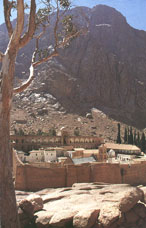
St. Catherine: Lies about 150 km. south-east of Abu Rodeis on a high plateau 2500 meters above sea level. It is considered the center of religious tourism in Sinai. Nearby lies the Monastery Of St. Catherine dating back to the 6th century. This town is famous for its orchids and plentiful water. The village compromises 100 bungalows and an elegant restaurant. Mount Sinai: ( as shown on left) " Among all the stupendous works of nature, not a place can be selected more fitting for the exhibition of the almighty" ( John lloyd Stephens)
Main Tourist Sites in South Sinai: Uyun Mussa: About 15 km. east of Suez, it is an oasis compromising 12 sweet water springs. Monastery of St. Catherine: This was built in the 6th century and dedicated to the daughter of a ruler of Alexandria, who converted to Christianity and was subjected to great torture. The huge walls of the Monastery surround a number of small churches. On the east wall is an ancient basket and a pulley which was used instead of opening the door.
Main Landmarks of the Monastery: The Mosque: Built in Fatmid age, stands west of the main church within the walls of the Monastery. Hammam Fara’un (Pharaoh’s Bath): A group of hot sulphur springs, with at temperature of 72 C at the source. Chapel of Aaron: Stands the plain of Al-Raha, Wadi Firan. Sourial Mountain: An object of pilgrimages prior to the advent of religions. Moses and Sefsafa Mountains: 2 km. long mountain chain, the highest peak of which Moses mountain (Gabal). Other Main Landmarks:
Fortresses: The Fortress of Sidr: Built by Salah al-Din al-Ayoubi. The Fortress of Nuweiba: Built by the Turks in the 18th century. The Fortress of Al-Tor: Built by Sultan Selim in 1520 AD. The Temple of Sarabit al-Khadim: Lies on a small hill top north of Al-Tor. It consists of several caves, most important of which are: Cave of the Goddess, Hathor, built during the reign of King Snefur, and the cave of Souidu, the God of War. Tomb of Nabi Saleh: Lies at the junction of Wadi Mur and Wadi al-Sheiekh.
Main Tourist
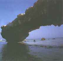
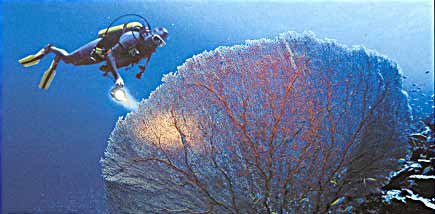
Beaches: Ras Mohammed: (shown to the right) situated at the peak of the Sinai Peninsula, 53 km. from Sharm Al Shiekh and its narrowest part between the Gulfs of Suez and Aqaba. It is renowned for having the most exquisite coral reefs in the world and for being a refuge to rare marine life. It has recently declared a nature preserve and most fit for diving. Sharm Al-Shiekh: Overlooks the Gulf of Aqaba, and is about 53 km. from Ras Mohammed and 336 km. from Suez. It is both a summer and winter resort due to its moderate climate all year round and depends on fishing and tourism. It is the Mecca of all those who seek tranquility and love the sun. There are several well equipped diving centers.
Dahab: About 81 km. north of Sharm Al-Shiekh, it is one of the most beautiful beaches in South Sinai because of its gleaming sand, clear waters and colorful marine life. It has a tourist village, diving centers, camping sites and boats and waterskiing facilities. Nuweiba: About 87 km. from Dahab on the aqaba Gulf, it is famous for its beautiful sandy beaches. It has a diving center, a tourist village, cafeteria and fish restaurant. Main Diving Centers:
General Information
| Cruises
| Hotels
| Tour
Operators |

 Abu
Rodeis: On the Gulf of Suez, is a center for extracting
petroleum. It has an airport that can handle small and medium size
aircrafts.
Abu
Rodeis: On the Gulf of Suez, is a center for extracting
petroleum. It has an airport that can handle small and medium size
aircrafts.